
Using Atmospheric Data to Determine Climate Indicators for Heat and Health Risks
![]() SDGs-EYES is a project funded by the European Union which aims at boosting the European capacity for monitoring and reporting the Sustainable Development Goals (SDGs). The following publication was created by the SDGsEYES Extreme Temperature Risk Pilot Team. The blog authors consist of Marta Ellena, Alessandro Pugliese, Mattia Scalas, from CMCC, Teresa Spadea and Nicolas Zengarini from the Epidemiology Unit (SEPI) of the Local Health Authority TO3 (ASLTO3) and Mónica Miguel-Lago from EARSC.
SDGs-EYES is a project funded by the European Union which aims at boosting the European capacity for monitoring and reporting the Sustainable Development Goals (SDGs). The following publication was created by the SDGsEYES Extreme Temperature Risk Pilot Team. The blog authors consist of Marta Ellena, Alessandro Pugliese, Mattia Scalas, from CMCC, Teresa Spadea and Nicolas Zengarini from the Epidemiology Unit (SEPI) of the Local Health Authority TO3 (ASLTO3) and Mónica Miguel-Lago from EARSC.
The objective of the pilot is “to integrate high-resolution atmospheric data provided by different state-of-the-art datasets from different spatial and temporal domains to define which climate indicators could be used within a risk framework that considers the link between heat and health (i.e., mortality and morbidity).” To learn more about the project, you can visit their website HERE.
Leveraging Earth Observations to Mitigate Heat-Related Health Risks: The Turin Pilot
With climate change driving more frequent extreme temperature events, cities are facing significant health challenges. Heatwaves have become the leading cause of weather-related deaths, particularly in Mediterranean countries like Italy. In the northern regions of the country, where the city of Turin is located, the elder and the most disadvantaged groups are experiencing a rise in heat-related fatalities. To address this challenge, one of the SDGs-EYES pilot is using Earth observation data to understand and manage heat-health risks in urban areas, with a focus on social inequalities and the built environment characteristics.
Integrating High-Resolution Atmospheric Data
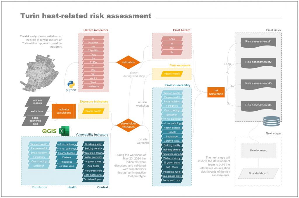
The pilot is combining demographic, socioeconomic, health and climate high-resolution datasets to study the link between heat and health. From the climate side, it draws on advanced data sources, including the Copernicus Climate Change Service (C3S). Datasets such as VHR-REA_IT (high-resolution dynamical downscaling datasets of ERA5), Copernicus Regional Reanalyses for Europe (CERRA), and complement by Urban Atlas Land Cover are capturing heat-stress evaluations (using appropriate indicators) and other environmental factors.
Researchers are assessing how the quality of the atmospheric data affects the accuracy of health risk predictions. The ultimate goal is to develop a Copernicus-based decision-making tool that will not only evaluate the impact of heat waves on health at the census tract scale within the city of Turin, but will also detect the most predictive factors of health effects, and identify the most vulnerable areas and socioeconomic subgroups of population to climate hazards. This tool will allow policy makers to set priorities for action by applying a health-equity approach required by the national and regional prevention plans, and will inform and help the governance in the planning process of policies for new climate change adaptation.
Decision Support for Policymakers and Urban Planners
A core element of this project is the development of a Decision Support System (DSS). This system allows health officials, urban planners, local authorities and citizens to interact with detailed maps and datasets, comparing different spatial resolutions and risk indicators. The DSS offers a user-friendly way to understand heat-related health risks and to apply effective adaptation and resilience strategies.
Impact on SDG 13: Climate Action
The pilot directly supports Sustainable Development Goal 13 (SDG 13), which focuses on addressing climate change. By developing tools that enhance climate resilience in cities, the project calls for strengthening resilience to climate-related hazards. The insights achieved so far are helping Turin and, mostly, providing a model for other cities facing similar challenges, showing the essential role of EO data in protecting public health.
Collaborative Efforts for Climate Resilience
Led by ASLTO3, this pilot involves partners like the Euro-Mediterranean Center on Climate Change (CMCC). Regional health authorities, urban planners, and academic institutions, such as the University of Turin, are working together to ensure that the findings benefit both health and urban planning sectors. Additionally, the pilot aimed at supporting organizations like the Turin Municipal Administration and Health Districts to get prepared for future heatwaves.
As extreme temperatures become more common, the ability to predict and manage health risks in urban areas is critical. This pilot, through advanced EO data and collaboration among key stakeholders, is paving the way for stronger climate resilience in urban areas.
More info: SDGsEYES project
Pilot: Extreme temperatures risk, City of Turin (IT)
Indicators: Mean near surface temperature deviation (urban)
Date Published: February 24th, 2025


