REACT – Remote sensing Environment, Analysis and Climate Technologies

Irena Hajnsek from ETH Zurich Switzerland and the German Aerospace Center, Germany is leading the IEEE Geoscience and Remote Sensing Societies Technical Committee named REACT. REACT has several local focus areas. Adnan Siddique and Jakob Steiner, from ITU Lahore, Pakistan and University of Graz, Austria, respectively, are co-leading the focus area on “Risks in High Mountain Asia.”
Connecting scientific advances in remote sensing with the urgent need to address climate change is a complex endeavor. It requires staying at the forefront of technical innovation, employing the right tools to process and communicate data, as well as understanding local and regional challenges, needs and capacities. REACT is a forum that brings together scientists and engineers to address these challenges with a bottom-up approach to meaningfully contribute to Sustainable Development Goals (SDGs) through remote sensing technologies. Local or regional problems are focused currently on five environmental problems and are led by experts in the domain, while keeping in the view the global relevance and transferability of the solutions to other regions across the world.
One of the local focus area of REACT is engaged with the risks in High Mountain Asia.
Risks in High Mountain Asia
With temperature rising faster at higher elevation than elsewhere, and infrastructure developing rapidly to exploit resources and connect countries across contested border regions, High Mountain Asia (HMA) faces a plethora of risks. These risks span from landslides, rockfall, debris flows, all the way to avalanches and flash flooding.
HMA spans high-elevation regions of several countries in central-South Asia, all the way westwards from Uzbekistan to parts of Mongolia and China (Tibetan Plateau) in the east, while covering large swaths of populations of northern India, Pakistan, Nepal and Bangladesh. Remote sensing applications in HMA encounter challenges posed by complex terrain, scarcity of validation data, and limited resources to develop capacities regionally to respond to these daunting risks. This Local Focus Area is working towards providing a pipeline to stakeholders in the region to state of the art technologies in remote sensing, and a potential to collaboratively develop relevant solutions.
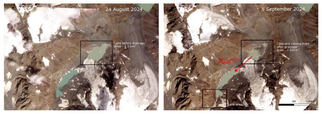
One such example is the development of rapid response reports (see a recent example from the Indus basin in Figure 1), including reports in local languages and coordination with local experts under the HiRISK platform. Rapid evaluation by experts and communication to local stakeholders – alongside a connection to existing scientific literature to analyse events – allows decision-makers to address risks in an informed manner, while being able to transparently trace the creation of knowledge.
Timely contextualization of hazard events
Risk Analysis with multi-modal satellite imaging technologies and climate data
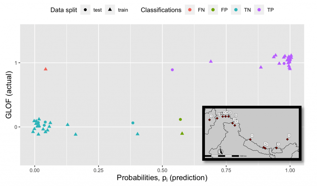
REACT leverages advanced optical and synthetic aperture radar (SAR) imaging technologies and the related processing techniques, as per the requirement of the concerned application. Experts working on the HMA focus area perform risk analysis using this imaging data in conjunction with time series of environmental variables. An example is the flood risk analysis for potentially dangerous glacial lakes in HMA, that may be prone to bursting under a heat wave or heavy precipitation (Figure 2). These lakes can be detected and delineated using advanced machine learning based approaches, such as deep learning for segmentation in spaceborne optical images (Figure 3).

Advancing SDG 13 through access to interpretations of climate risks
REACT promotes the achievement of SGD 13, by enhancing access to correct interpretations of climate risks. It’s a network that ties together and supports regional early career scientists engaged in the development of new technologies (SDG13.3). It facilitates various stakeholders in tackling the challenge of making regional institutions resilient to climate risk (SDG13.1), while informing the scientific community of the actual needs. To learn more about REACT, and the several other focus groups under REACT, please visit our website! If you intend to subscribe to our mailing list, please click here.
Date Published: January 13th, 2025


