
Protecting Belize’s Barrier Reef World Heritage Site
The main objective of this project, titled “Climate-influenced Nutrient Flows and Threats to the Biodiversity of the Belize Barrier Reef Reserve System,” is to study the impacts of eroded sediments and nutrients from Belize’s sixteen major watersheds on the coral reef health and biodiversity within the broader Belize Barrier Reef Lagoon system. The project supports the Government of Belize with reporting on indicators related to the Sustainable Development Goals (SDG) 14, Life below water and 15, Life on land.
The effort uses a time series approach for studying moderate-resolution NASA optical datasets, atmospheric correction algorithms developed by the research team for high accuracy over water bodies, and in situ measurements of both coral reef extent and water quality and nutrient load. While similar activities had previously been attempted in piecemeal fashion, this project seeks both to leverage Earth observation data in a way that had not previously been used, and to develop sustained local capacity to utilize such data for decision-making. The initiative is also working to strengthen the overall capacity of key institutions in Belize in the area of Earth observations for marine and terrestrial ecosystem monitoring.
Earth Observation Data Sources
Water quality indicators derived from the NASA and the United States Geological Survey Landsat-8 and the Copernicus Sentinel-2 missions; Land cover and land cover change derived from Landsat-5, Landsat-7, and Landsat-8, NASA’s Moderate Resolution Imaging Spectroradiometer (MODIS), and the Copernicus Sentinel-2.
Other Data Sources
Benthic habitat data derived by the Coastal Zone Management Authority and Institute from Landsat-5; Digital elevation model from the Shuttle Radar Topography Mission; Precipitation data from the WorldClim Consortium and from the Climate Hazards Group InfraRed Precipitation with Station data (CHIRPS); Climate change scenarios: Shared Socioeconomic Pathways from the Intergovermental Panel on Climate Change (IPCC)’s Coupled Model Inter-comparison (CMIP)6 and Representative Concentration Pathways from the IPCC’s CMIP5, sourced from the WorldClim Consortium; and, Soil data from the Soil and Terrain Database for Latin America and the Caribbean.
Progress
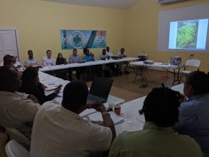
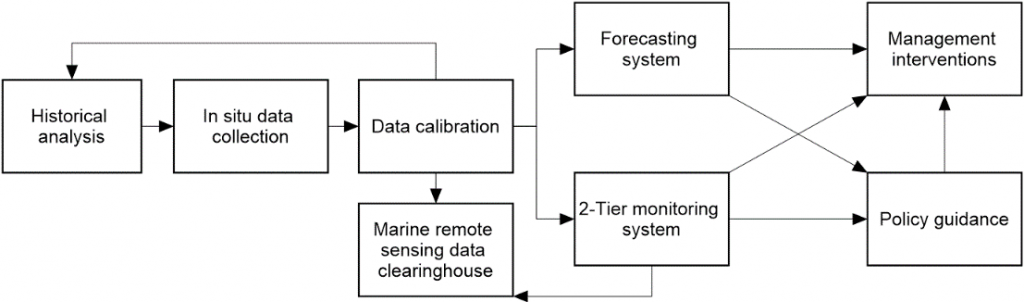
A soft launch of the project was completed in May 2019, including engagement visits to multiple stakeholder institutions, as well as a high-level briefing to the Chief Executive Officer of the Ministry of Forestry, Fisheries the Environment and Sustainable Development (MFFESD), a major Government of Belize line ministry. The study collected in situ water quality data for satellite data calibration in May 2019, November 2019, and May 2020. The team was able to acquire historical water quality data dating back 20 years from a private sector water quality lab. Finally, the project developed a Google Earth Engine (GEE)-based platform for use of NASA Landsat-8 and Copernicus Sentinel-2 data for monitoring Belize’s coastal waters as well as GEE-based apps for visualization.
Ongoing work includes:
– Developing Landsat-based time-series of Landsat-based water quality maps of Belize’s coastal waters
– Creating Landsat-based land cover change maps (for linking with the coastal water quality data)
– Modelling of future potential change in water quality, based on the IPCC CMIP6 model outputs
– Oceanographic modeling toward the coastal and marine water quality forecasting system
Outreach and Communications
A related virtual training on land use change monitoring was completed with national stakeholders’ participation in March 2020. The project’s first publication (in the EO4SDG special issue in Elsevier’s Remote Sensing of Environment journal) was released in May 2020. There is also ongoing engagement with regional institutions (e.g. Central American Integration System (SICA)) and projects (e.g. MAR2R), in support of the NASA-SICA collaboration. In addition, the study continues to leverage dedicated GEE project resources, including 2TB of cloud storage.
Workflow
Challenges
A key challenge is ensuring adequate coordination with the entities reporting on national SDG implementation as well as reporting up to the United Nations. Also important is ensuring that Earth observation data are appropriately integrated into the internal processes of the technical agencies responsible for monitoring Belize’s coastal, marine, and terrestrial ecosystems. Finally, circumstances resulting from COVID-19 have caused implementation delays.
Next Steps
As of July 2020, next steps for the project include capacity development and training activities in coastal and terrestrial monitoring; finalization of the calibration of satellite-based water quality indicators; completion and deployment of the marine forecasting system and the data clearinghouse (to feed into Belize’s Marine National Spatial Data Infrastructure); and provision of policy guidance to the Government of Belize regarding integration of Earth Observations into national reporting on SDG implementation.
Supporting Materials
- NASA Earth Observatory article on the project’s initial field activities: https://earthobservatory.nasa.gov/blogs/fromthefield/2019/06/03/on-the-ground-in-belize-to-improve-how-satellites-see-water-quality-from-space/
- Social media coverage of the project: https://twitter.com/search?q=BZ-SDG&src=typed_query&f=live
Publication
- Use of public Earth observation data for tracking progress in sustainable management of coastal forest ecosystems in Belize, Central America: https://www.sciencedirect.com/science/article/pii/S0034425720301681
Project Funding & Implementation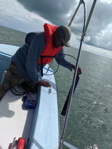
The project is funded by NASA’s Applied Sciences Program. “Building on NASA’s earlier work in Central America under the SERVIR program (implemented by USAID and NASA), the project is also a demonstration for the Earth Observations for the Sustainable Development Goals (EO4SDG) initiative,” noted project co-investigator Dr. Emil Cherrington (UAH).
Implementation is being led by four organizations: The University of Alabama in Huntsville (UAH), The University of Georgia (UGA), NASA’s Jet Propulsion Laboratory (JPL), and the Wildlife Conservation Society (WCS).
Project Principal Investigator
- Robert Griffin, UAH
Science Principal Investigator:
- Emil Cherrington, UAH
Co-Investigators:
- Alex Tewfik, Wildlife Conservation Society, WCS
- Christine Lee, NASA Jet Propulsion Lab
- Deepak Mishra, University of Georgia
Collaborators:
- Nicole Auil-Gomez, WCS
- Myles Phillips, WCS
- Vanesa Martin, UAH
End User Organization Representatives
- Andria Rosado, Belize Coastal Zone Management Authority & Institute, CZMAI
- Samir Rosado, CZMAI
Partner Organization Representatives
- Jorge Cabrera Hidalgo, Sistema de la Integración Centroamericana, SICA
View All Projects


