Announcing GEO SDG Awards 2020 Winners

Launched last year, the GEO SDG Awards Program, led by the EO4SDG initiative, recognizes institutions, organizations and countries that are applying Earth observations towards the achievement of the Sustainable Development Goals. We are pleased to announce the winners of the second annual GEO SDG Awards.
Fourteen awards were presented in both the “Sectoral” and “Special Categories”. And the winners are…
SECTORAL CATEGORY AWARDS
GEO Member: Ministry of Environment and Energy of Costa Rica; UK Space Agency
GEO Participating Organization: Global Partnership for Sustainable Development Data; UN-GGIM:Europe
SDG Custodian Agency: United Nations Convention to Combat Desertification
Not-for-Profit: HR Wallingford
Academia: The Earth Observatory of Singapore; The Rights Lab, University of Nottingham, UK
For-Profit: Geospoc; CirroLytix Research Services
SPECIAL CATEGORY AWARDS
Innovation: International Water Management Institute
Statistical-Geospatial Integration: Tanzania National Bureau of Statistics
Collaboration: GEO Blue Planet Initiative and Esri
Testimonial: CODATA, Committee on Data of the International Science Council
More information regarding the evaluation and selection criteria can be found here.
Ministry of Environment and Energy of Costa Rica for the GEO Member Award
The Mapping Nature for People and Planet Partnership, also known as the Big Enchilada, brings together scientists and policy experts to harness earth observations to identify essential life support areas (ELSAs) where nature-based actions can safeguard key biodiversity and ecosystem services. Led by the Ministry of Environment and Energy of Costa Rica (MINAE) together with UNDP, this partnership has created a scientific framework and decision support system to identify ELSAs, to take nature-based actions based on national priorities, and to monitor the impact of these actions. Our theory of change is that map-based, credible, high-quality information combined with capacity building at the national level will drive shifts in policy implementation and reporting to deliver on the 2030 Agenda and the Rio Conventions. Initially piloted in Costa Rica, the partnership is now evolving in Colombia, Kazakhstan, Peru, and Uganda, using spatial data to place nature at the center of sustainable development.
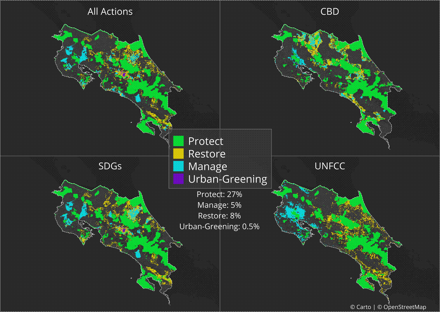
‘Maps of hope’ for Costa Rica show Essential Life Support Areas where actions to protect, manage, and restore nature can deliver on national priorities associated with the 2030 Agenda for Sustainable Development, the Convention on Biological DIversity, and the UN Framework Convention to Combat Climate Change. Maps: Open Street Map and Carto
UK Space Agency for the GEO Member Award
The UK has world-leading satellite EO capability, from developing and building missions to managing and exploiting data and creating trusted applications and services for use in the wider economy. The UK Space Agency is responsible for all strategic decisions on the UK civil space programme and the policy lead for satellite Earth observation (EO). Its International Partnership Programme (IPP) is the world’s largest ‘space for sustainable development’ initiative, funding 43 projects across 47 developing countries in Africa, Asia-Pacific and Latin America to the tune of £150M. The majority of projects use satellite EO to deliver economic, societal and environmental benefits to tackle development challenges and are already demonstrating real impact, e.g. an estimated 40 million hectares of forests are already being monitored using IPP-funded EO solutions (an area equivalent to all the forests in the UK, France, Spain and Switzerland combined) and one million hectares (more than times the size of London) of deforestation has been avoided.
Global Partnership for Sustainable Development Data for the GEO Participating Organization Award
Seeking to support African countries in their quest to leverage Earth observation data for the achievement of the Sustainable Development Goals, the Global Partnership for Sustainable Development Data (GPSDD) brought together a coalition of expert partners to establish the Africa Regional Data Cube (ARDC) initiative. ARDC was an open platform comprising 17 years’ of time-series satellite data, made available along with problem solving support, capacity building and peer learning activities. The founding partners included: NASA/CEOS, the Group on Earth Observations, Amazon Web Services, the Government of Kenya, and Strathmore University in Nairobi. Via the ARDC, the group supported 6 African UN Member States (Ghana, Kenya, Senegal, Sierra Leone, Tanzania and Zanzibar) to establish required governance infrastructures, user communities and development of applications, use cases and algorithms. Some of the challenges tackled at a country level included: water quality, coastal erosion, deforestation, monitoring crop phrenology and flooding, among others. These use cases will continue to be explored on Digital Earth Africa, a scaled-up continental partnership and platform that is replacing the Africa Regional Data Cube.
More info: https://www.data4sdgs.org/initiatives/digital-earth-africa
UN-GGIM Europe for the GEO Participating Organization
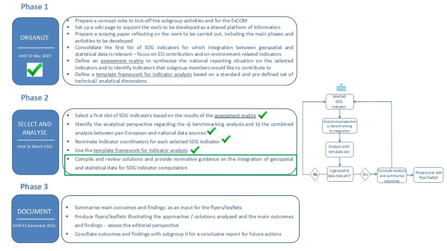
UN-GGIM: Europe is the regional committee of the United Nations Committee on Global Geospatial Information Management. The Regional Committee’s activities, particularly of its Working Group on Data integration, take into account the UN 2030 Agenda and the Sustainable Development Goals. The implementation of the SDGs requires the collection, analysis and availability of an unprecedented amount of geospatial data and statistics at global, regional, national and sub-national levels. The use of Earth observation data for the computation of statistical indicators is positioned in relation to geospatial layers derived from EO data, taking into account that a primary use of EO data implies specific technical capacities for its processing and editing. With references to CEOS, GEO and to services based on EO and in-situ data made available by the European Copernicus Programme, the aim of Working Group is to provide methodological, operational and technical guidance in the use of geospatial data and statistics to compute SDG indicators, focusing a European and national perspective.
United Nations Convention to Combat Desertification for the Custodian Agency Award
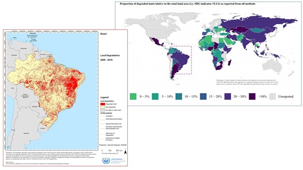
The United Nations Convention to Combat Desertification (UNCCD) is the sole legally binding international agreement linking environment and development to sustainable land management. In its capacity as Custodian Agency for SDG Indicator 15.3.1 “proportion of land that is degraded over total land area”, the UNCCD has been supporting national uptake of Earth Observation (EO) methods, data and tools for land degradation monitoring and catalyzing political commitment in countries for the setting of voluntary Land Degradation Neutrality targets. To facilitate reporting, the UNCCD has made available to all 196 countries signatory to the Convention national estimates of land degradation derived from available global data of land cover, land productivity and soil organic carbon stocks. More than 300 representatives from 140 countries have benefited from UNCCD’s capacity development support, which led to the release of the first global assessment of land degradation in early 2019, based on 123 country submissions and 40 estimates derived from global EO data sources.
HR Wallingford for the Not-for-Profit Award
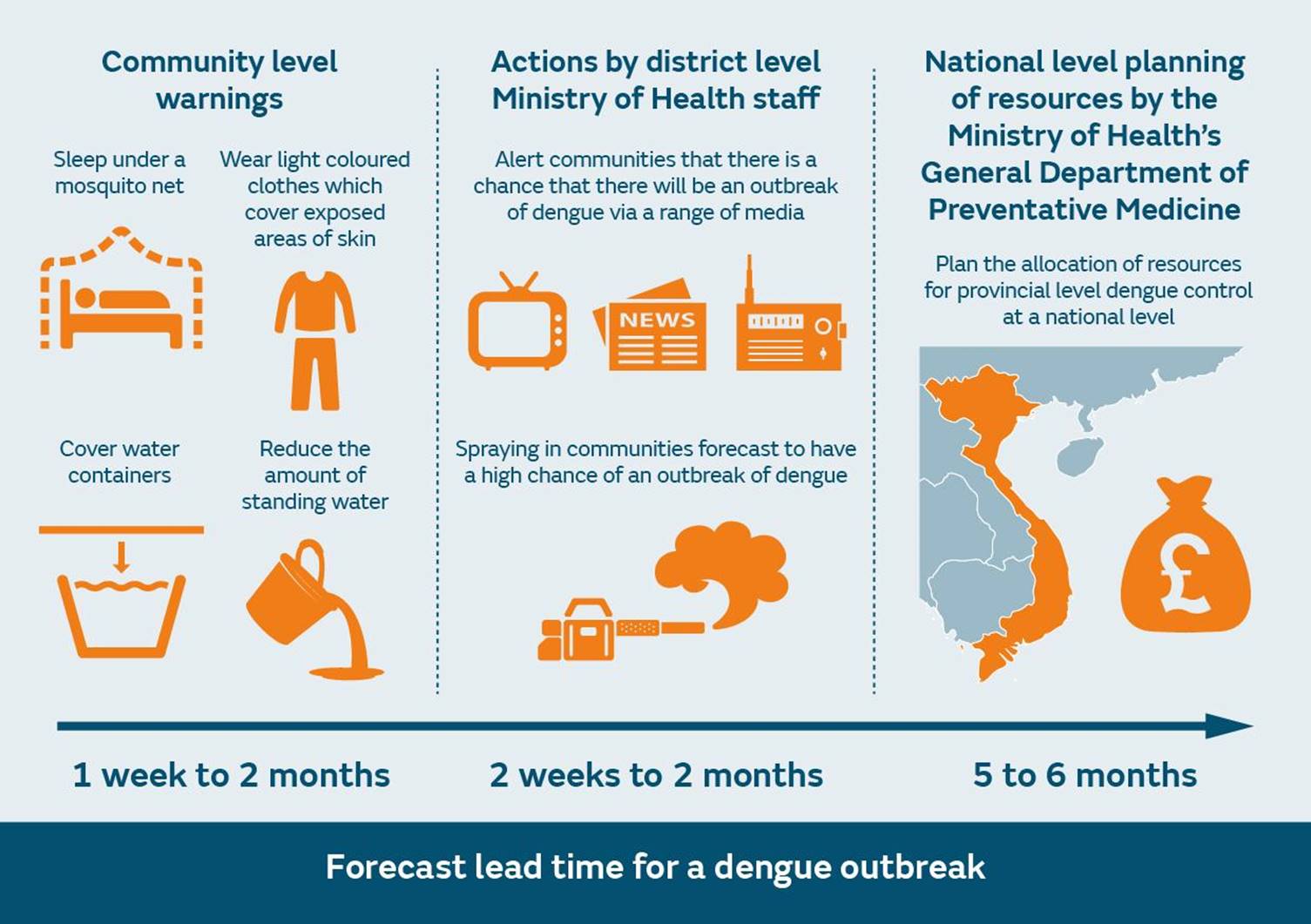
HR Wallingford is an independent, not-for-profit, research organisation that carries out consultancy and research in early warning systems, earth observation technologies, climate change, climate resilience and the water environment worldwide. HR Wallingford is leading the Dengue MOdel forecasting Satellite-based System (D-MOSS) project, which is funded by the UK Space Agency’s International Partnership Programme.
Dengue is the fastest spreading mosquito-borne disease in the world today. Vietnam has suffered some major outbreaks of dengue fever in recent years. Until this project, Vietnam had no system in place to forecast the probability of dengue outbreaks. The D-MOSS system predicts the number of cases of dengue fever on a monthly basis up to six months in advance. It is the first fully integrated dengue fever forecasting system incorporating Earth Observation data, in-situ observations and seasonal climate forecasts, to issue warnings on a routine basis. It allows government officials to issue warnings of likely outbreaks, to better target mosquito control and community awareness activities, and to improve their planning and prevention measures. For more information, please see here: https://www.hrwallingford.com/projects/d-moss-dengue-forecasting-model-satellite-based-system
Earth Observatory of Singapore for the Academia Award
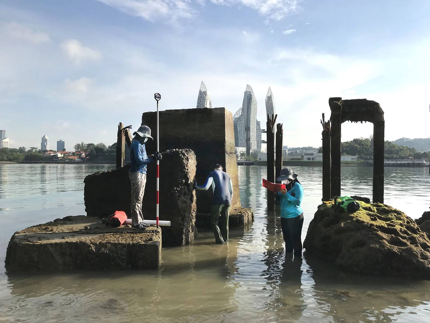
The Earth Observatory of Singapore (EOS) has two objectives: to acquire scientific knowledge on complex natural phenomena affecting Southeast Asia and to communicate these in an effective and timely fashion. In synergy with the Asian School of Environment, Nanyang Technological University, EOS projects use Earth Observation datasets to support global resilience and sustainability. Examples include the Advanced Rapid Imaging and Analysis-Singapore project, in collaboration with the NASA-JPL and Caltech, which uses satellite data to provide timely maps for post disaster situations, thus, supporting SDGs 11, 13, and 17.. Other EOS projects support sustainable cities and communities (SDG 11) by analysing risks from anthropogenic hazards and studying the role of nature-based solutions. New research from the Southeast Asia SEA-Level program at EOS also supports climate action (SDG 13) by leveraging EO data to improve the accuracy of sea-level research and to communicate these to the appropriate authorities.
The Rights Lab, University of Nottingham, UK for the Academia Award
The Rights Lab houses the world’s leading modern slavery experts. We have built a large-scale research platform for ending modern slavery, responding to the UN Sustainable Development Goal Target 8.7. Through our five programmes, we deliver new and cutting-edge research that provides rigorous data, evidence and discoveries for the global antislavery effort. The satellite EO-driven “Slavery from Space” programme, led by Doreen Boyd, affords understanding of distribution and prevalence of a form of human rights abuse typified by hidden populations (modern slavery) – a crucial first step in its eradication. We use EO to identify and track over time the scars left on the Earth by the industries known to have high levels of exploitative labour practices. Since SDG Target 8.7 intersects other SDGs, and in delivering against it, the Lab contributes to the wider sustainable development agenda. As such, a number of NGOs and governments now use our EO-derived intelligence.
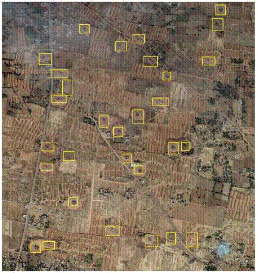
Bull’s Trench Brick Kilns across the Brick Belt of south Asia – locations of reported exploitative labour practices but lack of knowledge of kiln numbers/locations. We mapped from VHR imagery using machine learning all the tens of thousands of kilns and are now working with UNDP India and VSJ on underpinning their systems for governance of these kilns.
Geospoc for the For-Profit Award
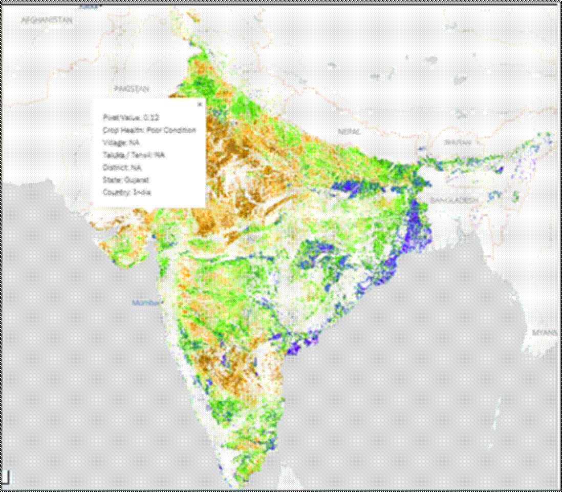
Geospoc is using the combination of artificial intelligence and machine learning to unlock the potential of satellite data. By adding the power of cloud computing, we are enabling ‘on-the-fly’ analysis and insights from large datasets. This enables our solution to be used by people without expertise or training – which thereby increases the adoption and proliferation of this technology. Projects with clients such as UNICEF involved in building algorithms to identify schools and hospitals from satellite data. This will enable them to create a comprehensive database of critical facilities required in rural areas of developing countries. The Kerala government whom we helped use satellite data to visualise the extent, magnitude, and height of flooding In Kerala, India. Leading Crop insurance companies in India to get real time information on crop health and generate automated reports. Geospoc works to contribute towards multiple social development goals such as SDG 11(11.5,11. b) SDG 8 (8.1, 8.4,) SDG 1(1.4, 1.5) SDG 4 (4.1, 4.2).
CirroLytix Research Services for the For-Profit Award
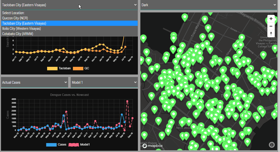
CirroLytix Research Services was formed to create social impact through big data. Through the application of machine learning, data engineering, remote sensing, and social listening the Philippines-based data analytics firm hopes to help governments, researchers, NGOs, and social enterprises achieve positive change. Project AEDES is one of the CirroLytix’s flagship projects, combining digital, climate and remote sensing to nowcast dengue trends and detect mosquito habitats to help preempt cases of dengue. The AEDES process leverages NDVI, FAPAR, and NDWI readings from Landsat and Sentinel-2 to estimate still water areas on the ground, which is correlated with dengue case counts from national health centers. Aside from dengue, the company also supports COVID-19 modeling and response initiatives with the public health sector. The company is also continuing to update the AEDES framework to include socio-economic risk mapping to turn it into a health and environmental policy tool. CirroLytix’s current involvements include public health, human rights, fighting disinformation, education and food security.
International Water Management Institute for the Innovation Award
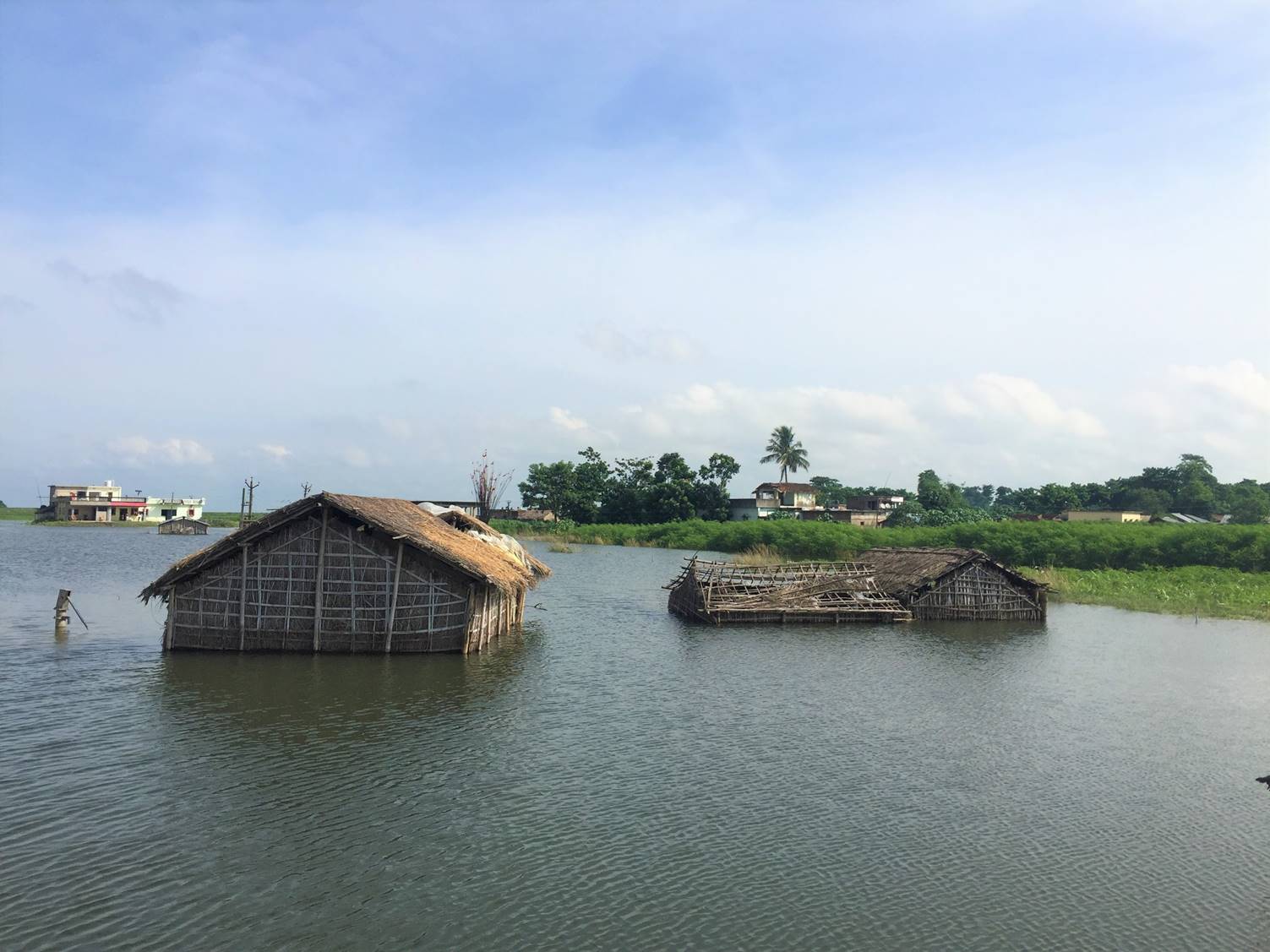
Photo source Dakshina Murthy / IWMI
The International Water Management Institute (IWMI) is a research-for-development (R4D) organization, with offices in 13 countries and a global network of scientists operating in more than 30 countries. For over three decades, our research results have led to changes in water management that have contributed to social and economic development. In South Asia, climate change is magnifying the risk from extreme weather events and increasing associated economic losses. Insurance can transfer risk from weather-related disasters but is often too expensive for poor farmers to afford. IWMI scientists used satellite technology to create a low-premium, index-based insurance to compensate poor and vulnerable farmers for damage to their crops from flooding. Data on historic floods underpinned a model that predicted where flooding was likely, while combined flood-risk and socioeconomic data informed pricing. Using earth observation data to verify claims negated the need for extensive field visits, which kept the premiums affordable and enabled claims to be settled quickly. Trials conducted in India and Bangladesh resulted in thousands of farmers receiving payouts. Expansion of such schemes could help bolster farming livelihoods, reduce post-disaster costs for governments, and contribute to meeting Sustainable Development Goals on climate change, poverty, gender equality and food security.
Tanzania National Bureau of Statistics for the Statistical-Geospatial Integration Award
Use of Earth observation data in monitoring the UN Sustainable Development Goals
The major environmental problems facing Tanzania are land degradation, lack of accessible, good quality water for urban and rural inhabitants, environmental pollution, loss of wildlife habitats and biological diversity, deterioration of aquatic systems and deforestation. The climate is tropical and coastal areas are hot and humid, while the north western highlands are cool and temperate. There are two rain seasons; the short rains are generally from October to December, while the long rains last from March to June. The central plateau tends to be dry and arid throughout the year. The National Bureau of Statistics (NBS) has been using Earth observation data in monitoring the UN Sustainable Development Goals as per mentioned problems and challenges above. Other works to access the growth pattern of Tanzania cities, land change and land fractional cover have been done using Earth observation data and the results have been shared with other Government Institution for usage.
GEO Blue Planet and Esri for the Collaboration Award
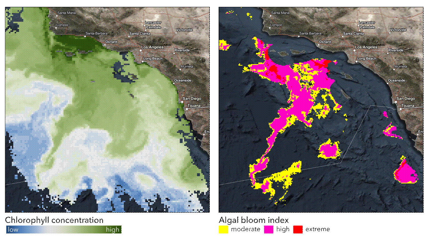
Sustainable Development Goals (SDGs) require timely and objective reporting. Many countries do not have in-situ nutrient measurements to monitor water quality and therefore need other tools to quantify eutrophication and monitor progress on SDG 14.1.1a – Index of Coastal Eutrophication. To support this need, GEO Blue Planet and Esri formed a partnership to develop and execute a methodology for quantifying the impact of eutrophication using satellite-derived chlorophyll-a measurements. Esri, through ArcGIS Pro, used a series of ModelBuilder models and provided the statistics for the global indicators for eutrophication so the data can be included in the 2021 SDG Progress report. The collaboration involves developing dashboard applications that include information on chlorophyll-a deviations from baseline values and daily chlorophyll-a anomalies. These tools will assist countries by identifying locations of potential eutrophication hot spots and target in situ nutrient sampling. For more information visit the SDG 14.1 Hub Site (https://chlorophyll-esrioceans.hub.arcgis.com).
CODATA, Committee on Data of the International Science Council for the Testimonial Award
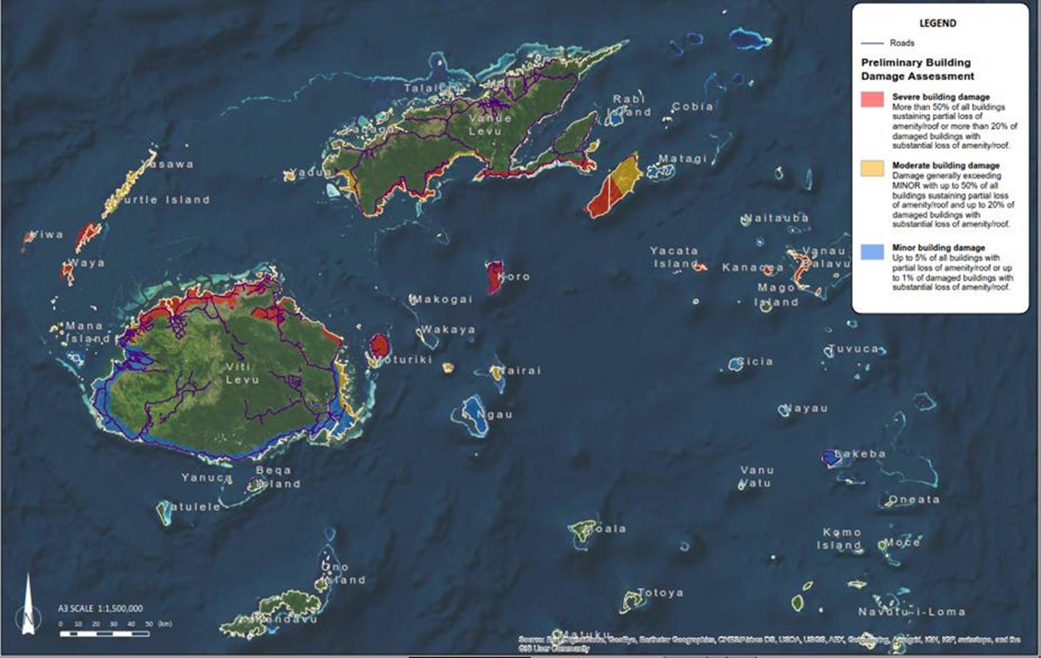
Tonkin + Taylor (T+T) is New Zealand’s leading environmental and engineering consultancy. T+T focuses on people, communities, cities and human settlements and creating sustainable future-proof infrastructure – while maintaining a care for the environment. T+T has partnered with ChinaGEO CDDR, RADI, the CODATA Task Group on FAIR Data for Disaster Risk Research and IRDR to provide Rapid Damage Mapping (RDM) work in the Asia-Pacific region since 2016. Using LIDAR, satellite images, and other Earth observational data, RDM provides factual spatial information and is fundamental in aiding an efficient, effective disaster response and recovery. This information helps determine the most critical infrastructure to rebuild, ensuring that cities are safer and more resilient after disasters.
RDM has significant social, economic and environmental benefits. It saves lives by sending aid where it is most needed, saves money by reducing unnecessary aid response in less severe areas, and protects the environment by identifying and putting plans in place to fix any environmental threats. In relation to SDGs, RDM and disaster response helps with #1 (no poverty), #2 (zero hunger), #3 (good health and well-being), #6 (clean water and sanitation), and #7 (affordable and clean energy) by providing aid where it is most needed, ensuring that all people and communities affected by a disaster gain access to food, healthcare, water, and other important utilities as soon as possible
View All News


