Announcing the 2025 GEO SDG Award Winners
We are proud to share with you the 6 winning groups of the 6th annual GEO SDG Awards Program! Launched in 2019, the EO4SDG initiative and the GEO Secretariat began recognizing institutions, organizations, and countries that are applying Earth observations towards the achievement of the Sustainable Development Goals. We received 38 nominations this year, each of which was carefully reviewed by nine panelists representing various countries and sectors. Submissions were reviewed for overall impact, quality and soundness of the Earth observation endeavors, and gauging their potential to be replicated and scaled up. We congratulate each of our Sectoral and Special Category winners for their exemplary work! Thanks to all who contributed to advancing the 2025 cycle!

SECTORAL AWARDS
GEO Participating Organization: International Institute for Applied Systems Analysis (IIASA), University of the Aegean, Scidrones, Ghana Statistical Service (GSS), Ghana Environmental Protection Agency (EPA), United Nations Sustainable Development Solutions Network (SDSN)
GEO Participating Organization: International Research Center of Big Data for Sustainable Development Goals (CBAS) and Aerospace Information Research Institute Chinese Academy of Sciences (AIRCAS)
Academia: Center for Remote Sensing, Institut Teknologi Bandung (CRS-ITB) and Geospatial Intelligence Solutions for Sustainability Action (GISACT)
SDG Custodian Agency: Food and Agriculture Organization of the UN (FAO) and Government of Zimbabwe
GEO Member Country: Statistics Indonesia (BPS)
SPECIAL AWARDS
Collaboration: European Space Agency (ESA)
GEO Participating Organization: International Institute for Applied Systems Analysis (IIASA), University of the Aegean, Scidrones, Ghana Statistical Service (GSS), Ghana Environmental Protection Agency (EPA), United Nations Sustainable Development Solutions Network (SDSN)
Citizen Science for the SDGs (CS4SDGs)
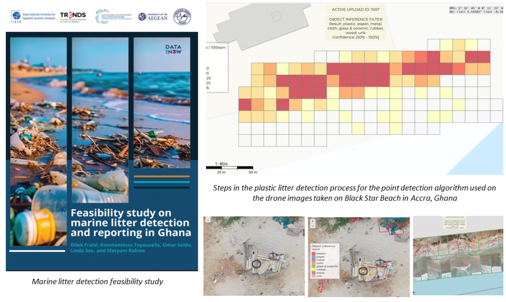
This project addresses key data and policy gaps in analyzing marine plastic litter patterns in Ghana, which became an issue of national priority. Building on Ghana’s pioneering work in incorporating citizen science beach litter data into official statistics and reporting for SDG indicator 14.1.1b during the initial phase of the project, CS4SDGs explored the integration of citizen science, drones, and AI to develop litter density maps along Ghana’s coastline, aiming to enhance SDG monitoring and support policy development. In a case study conducted as part of the second phase of the project, captured drone images were processed using the Coastal Marine Litter Observatory (CMLO) system, which successfully detected plastic litter and created a concentration map. The project also identified the need to refine AI algorithms using citizen science data, such as through the IIASA Picture Pile application, to enhance accuracy.
Moving forward, capacity building activities are planned to be held to equip local partners with skills in drone operation, GIS, and machine learning data analysis techniques, as this will empower national institutions to continue marine litter monitoring independently. Other countries aiming to tackle similar challenges can adopt this methodology developed to guide integration of citizen science into other SDG indicators. For example, Sierra Leone has organized knowledge exchange workshops with Ghana in replicating the citizen science data validation and reporting process for SDG 14.1.1b. The project was also recently featured as a success story on the UN Statistics Division website. A comprehensive analysis of the work is available in a technical report published as part of the project.
GEO Participating Organization: International Research Center of Big Data for SDGs (CBAS) and Aerospace Information Research Institute Chinese Academy of Sciences (AIRCAS)
Big Earth Data in Support of SDG 15: Life on Land
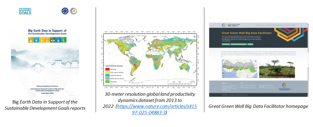
Founded in 2021, the International Research Center of Big Data for Sustainable Development Goals (CBAS) is committed to utilizing big data to support the 2030 Agenda. The center performs interdisciplinary research across fields such as Earth system science, social and economic sciences, and sustainability science. With backing from CBAS and the Aerospace Information Research Institute, Chinese Academy of Sciences (AIRCAS), the “Big Earth Data in Support of SDG 15: Life on Land” project is at the forefront of combining advanced Earth Observation (EO) technologies with big data analytics to tackle global issues related to land and biodiversity, directly influencing SDG 15 monitoring and intervention.
The project has developed an array of geo-spatial products focusing on land and biodiversity, including land productivity dynamics (LPD) and key areas for biodiversity conservation. It has also created an online platform, “GGDBDF,” to promote Land Degradation Neutrality (LDN). This platform employs various earth observation data sources (such as SDGSAT-1), big data analysis technologies, and Chinese expertise in desertification control to support the African Great Green Wall initiative. Furthermore, the project has contributed to a series of reports titled “Big Earth Data in Support of Sustainable Development Goals.” These achievements position the project as a global exemplar in applying big data and EO for sustainable development, offering scalable solutions that can be utilized by diverse stakeholders.
Academia: Center for Remote Sensing, Institut Teknologi Bandung (CRS-ITB) and Geospatial Intelligence Solutions for Sustainability Action (GISACT)
GeoIntelligence Platform for Mapping and Detecting Illegal Waste Dumping Along the Citarum Riverbank Using Integrated Satellite Data, UAV, and Participatory Mapping
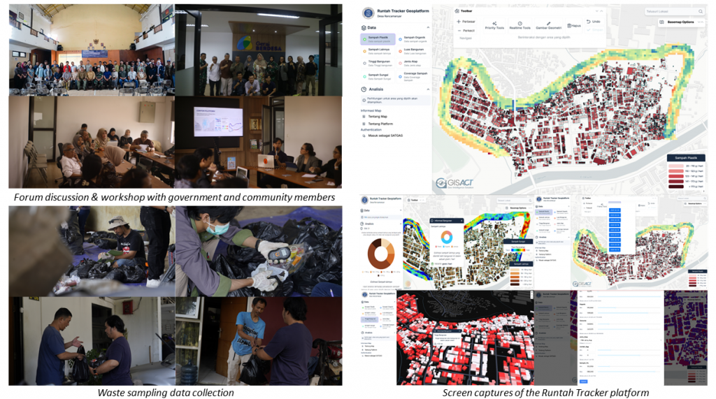
CRS-ITB pioneered a Geo-Intelligent Platform harnessing Earth observation and AI-driven analytics to detect and predict illegal waste dumping along the Citarum River. Integrating Sentinel-1, Sentinel-2, Landsat 8, VIIRS Night Light, Pleiades, and UAV data, it maps waste hotspots, models waste migration, and supports a Geospatial Decision Support System for targeted interventions. The impactful collaboration between CRS-ITB, GISACT, the Citarum Harum Government Task Force, West Java Province Government and local communities exemplifies how geospatial innovation can empower environmental monitoring and sustainable development.
The science-based initiative led by Dr.Eng. Anjar Dimara Sakti developed a novel algorithm enabling the continuous monitoring of plastic waste in river networks using Sentinel-2 satellite imagery. Building upon this research, the team launched the Runtah Tracker — with Runtah meaning “waste” in the Sundanese language — a cutting-edge geospatial intelligence platform integrating high-resolution satellite imagery, UAV mapping, Sentinel-2 data, and participatory reports from local communities. It enables real-time detection of plastic debris, prioritizes critical intervention zones, and visualizes structural features and river morphology related to pollution pathways. Moreover, it identifies potential waste bank locations, supporting circular economy practices in the region.
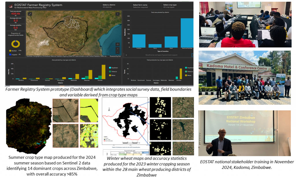
SDG Custodian Agency: Food and Agriculture Organization of the UN (FAO) and Government of Zimbabwe
EOSTAT-Zimbabwe
FAO, through funding from the African Development Bank and in close collaboration with the Ministry of Lands, Agriculture, Fisheries, Water and Rural Development, the Zimbabwe National Statistical Agency, and other national institutions, launched the EOSTAT-Zimbabwe project in 2023. The initiative aimed to operationalize the use of Earth Observation (EO) data for agricultural monitoring, food security planning, and disaster risk reduction. By institutionalizing EO-based tools, the project is strengthening Zimbabwe’s capacity to produce official crop statistics and assess the impacts of climate-related hazards.
Key achievements under EOSTAT so far
— Development of the first national winter wheat map (2023), covering 28 districts, with 95% overall accuracy and 96% precision for wheat classification.
— Production of the first national summer crop type map (2024), classifying 14 major crops with 77% overall accuracy, using the Sen4Stat system and Sentinel-2 data.
— Deployment of the Sen4Stat system both on the cloud and locally installed at the Zimbabwe Centre for High Performance Computing (ZCHPC), enabling national stakeholders to independently process and analyze EO data.
— Creation of a national survey frame and in-situ data collection protocol for crop type mapping, now under review for adoption by ZIMSTAT.
— Implementation of a regression estimator to derive crop acreage statistics by integrating EO maps with national survey data, with the result of increasing accuracy of national and district level statistics, and reducing costs.
— Launch of a High-Resolution Drought Monitoring System, calibrated for Zimbabwe’s crops and climate, allowing field-level assessment of drought severity and temporal trends.
— Joint operationalization of flood monitoring and anticipatory action systems with WFP, using the ADAM platform and integration with national platforms such as PRISM.
— Development of a prototype Farmer Registry System, linking field parcel boundaries with social survey and crop type data, enabling tracking of productivity, subsidies, and government incentive impacts.
— Organization of a national Mapathon with the National University of Science and Technology (NUST), leading to the digitization of over 200,000 crop fields across 7 districts.
— Training of over 25 national experts from ministries, ZIMSTAT, ZINGSA, CHPC, and others in crop mapping, yield modeling, and disaster monitoring using EO tools.
— Strong inter-institutional collaboration, establishing a national working group that includes the Ministry of Agriculture, ZIMSTAT, ZINGSA, CHPC, Meteorological Services Department, and other public agencies.
— This multi-faceted initiative is a model for sustainable EO integration into national statistical systems, contributing directly to SDG indicators and to the resilience of Zimbabwe’s agriculture sector.
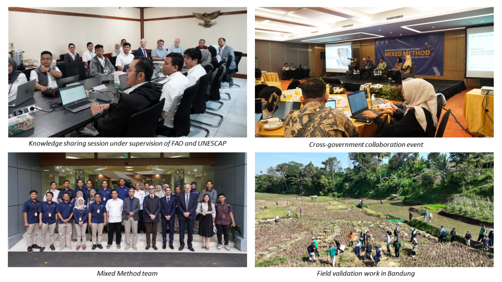
GEO Member Country: Statistics Indonesia (BPS)
Modernising Agricultural Official Statistics: Integrating Satellite Imagery and Machine Learning for Paddy Phenological Stages Area Estimation
Statistics Indonesia developed the Mixed Method, which integrates satellite imagery with the existing Area Sampling Frame (ASF) to strengthen the accuracy and efficiency of agricultural data collection. By combining ground-based surveys with Earth observation, this approach enables more timely and comprehensive monitoring of crop conditions, particularly in remote or hard-to-reach areas. The use of machine learning further enhances the ability to detect and classify paddy growth stages, supporting better-informed agricultural planning and decision-making. This modernized method directly contributes to Sustainable Development Goal 2 (Zero Hunger) by improving data availability for food security monitoring, resource allocation, and efforts to enhance sustainable agricultural productivity. Recognized by FAO and UNESCAP, this replicable EO-based model serves as a complementary tool to official statistics, enhancing data insights rather than replacing traditional methodologies.
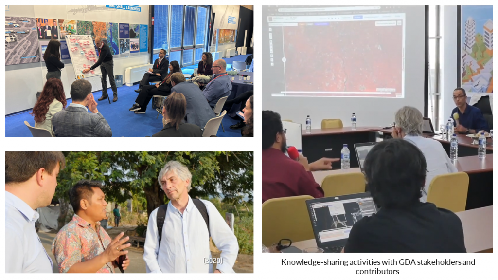
Collaboration: European Space Agency (ESA)
Global Development Assistance (GDA) Programme
The European Space Agency’s Global Development Assistance (GDA) programme is a global partnership to accelerate impact by mainstreaming and fully capitalizing on the power of satellite EO in international development assistance. GDA is implemented through a cooperation framework with International Financial Institutions such as the World Bank, ADB, IDB, and IFAD, set up to optimize mobilisation of complementary expertise and resources – allowing for a truly demand-driven approach where sustainable uptake and adoption at scale are core objectives. Through GDA, more than €100 million have been mobilised from both space and development finance resources, dedicated to scaling EO in development operations. As of April 2025, GDA boosts more than 100 different project engagements in 75 developing countries across 11 thematic domains. ESA’s international development cooperation efforts through GDA have been lauded by partners as “vital for improving the value proposition of development interventions, better decision-making, and taking action” and as “game changer for development.”
Date Published: April 25, 2025


