
Using satellite-based Earth observations to monitor SDG 6 indicators
In collaboration with GEO and space agencies such as NASA, ESA and JRC, the UN Environment has initiated efforts to provide countries with Earth observations products that can be used with nationally generated data to support monitoring of SDG 6 Indicators 6.6.1, Change in the extent of water-related ecosystems over time and 6.3.2, Proportion of bodies of water with good ambient water quality.
Background
Global monitoring of SDG 6, Ensure availability and sustainable management of water and sanitation for all, was initiated in early 2017 following development, testing, and evaluation of methodologies for monitoring the associated indicators. UN Environment is the custodian agency for Indicators 6.6.1 and 6.3.2, and has developed step-by-step methodologies to monitor factors that are associated with these indicators—such as changes in water quality, water quantity, and spatial extent. The methodologies provide an explanation of how to monitor these changes over time, and include definitions, computational steps, and recommendations on spatial and temporal resolutions.
In coordination with NASA, ESA, and JRC, UN Environment is looking to explore Earth Observations contributions to meet the reporting requirements of the two aforementioned indicators and help: (a) generate a reference baseline against which change in spatial extent of water-related ecosystems can be measured and future monitoring can be compared, and (b) provide maps and estimates of open waterbodies extent using moderate and high resolution remote sensing products as well as water quality indicators including total suspended solids and chlorophyll-a products for inland waterbodies.
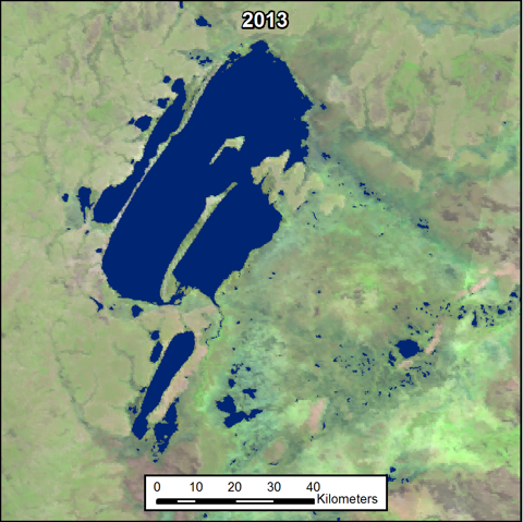
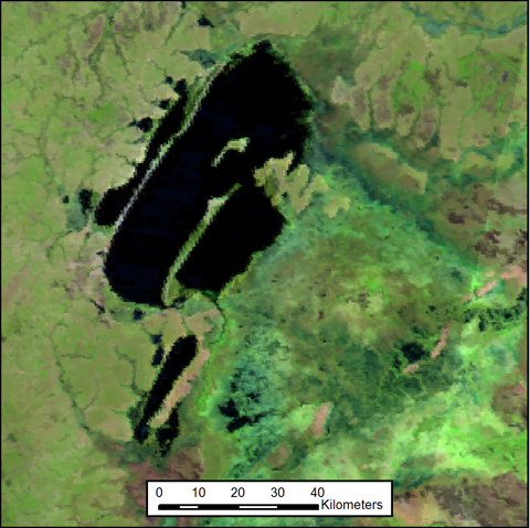
Upon consultation with UN Environment, a NASA-University of Maryland research team carried out a pilot study, focusing on one or more of the following countries: Senegal, Peru, Jamaica, Nepal, Cambodia, Philippines, Uganda, and Zambia. In particular, the analyses provided reporting on the spatial extent of coastal mangroves, at national scale, for the countries of Jamaica, Peru and Senegal, and the spatial extent of open waterbodies, at national scale, for the countries of Cambodia, Jamaica, Peru, Philippines, Senegal, Uganda and Zambia. Further, the team provided a proof of concept for the extraction of water quality indicators, such as Total Suspended Solids and Chlorophyll for select large open waterbodies in the countries of Peru, Senegal and Zambia.
Figures Reference: Vermote, E., et al., 2015, MOD09A1: MODIS/Terra Surface Reflectance 8-Day L3 Global 500m SIN. Version 6. NASA EOSDIS Land Processes DAAC, USGS Earth Resources Observation and Science (EROS) Center, Sioux Falls, South Dakota (https://lpdaac.usgs.gov), accessed 06 23, 2017, at http:// dx.doi.org/10.5067/MODIS/MOD09A1.006
Supporting Material
Follow the links below to access the research team presentations as well as a user guide (forthcoming), which provides an overview of the Earth observation products, methodologies, and recommendations on how to use the derived products – based on the assumption that users are working in ArcGIS or other GIS platforms. For now, the respective research groups will make the necessary data files available to interested parties directly using a method that works for all involved; ultimately, the derived datasets will be published on an online database.
The user guide serves as a proof of concept for similar future applications and provides a means for countries to replicate and adapt the successful methods to meet their needs. All of the Earth observation datasets that were used are of global coverage, publicly available and free of charge. In its custodian agency role, UN Environment will collaborate with countries to efficiently distribute the Earth observations methods and datasets to support their data-driven decision-making regarding these indicators.
Presentations, User Guide, and Technical Brief
Follow the links here to download: the NASA-University of Maryland research team’s presentations; the draft user guide on the use of satellite-based Earth observations datasets and respective tools for SDG indicators 6.6.1 and 6.3.2; and a two-page technical brief.
Additional Information
Learn all about monitoring SDG 6 on water and sanitation
Change in the extent of water related ecosystems over time (Indicator 6.6.1)
Proportion of bodies of water with good ambient water quality (Indicator 6.3.2)
View All Projects


